“Random encounters with the unusual” is a repository for the oddities that me and Mrs J have encountered on our travels, which we find interesting or amusing in some way. Have a look, maybe you will find something interesting or amusing herein.

Showing posts with label Hill Forts. Show all posts

Thursday, 9 July 2015

The Warminster Thing

The prominent hill shown in the below pictures is Cley Hill, which is just to the west of Warminster in Wiltshire. Cley Hill was once the location of an Iron Age hill fort and evidence of the earth works can still be seen today, along with two Bronze Age round barrows.

Local legend proposes that Cley Hill was formed by the Devil when he dropped a sack of earth which he was taking to Devizes to dump on the town. It is said the Devil was angry with the citizens of Devizes for converting to Christianity so he set off to bury the town by way of revenge. On his way to Devizes the Devil stopped to ask an old man the distance to the town. The old man, realising he was talking to the Devil, replied that he had been walking for years to reach Devizes. Disheartened, or feeling lazy, the Devil abandoned his plan and dropped the earth where he was, forming Cley Hill. A similar local legend surrounds Silbury Hill in Wiltshire, where this time the Devil was forced to drop earth he was carrying to bury the town of Marlborough. Clearly these legends are how folk tales try to explain these seemingly out of place stand-alone mounds.

In more recent times Cley Hill along with nearby Cradle Hill (to the North East of Warminster) have become places of pilgrimage for UFO Spotters hoping to have an experience with the Warminster Thing.

The story of the Warminster Thing starts on Christmas morning 1964 when a number of people in Warminster were awoken by a series of strange noises. The sounds in question were described by some of the witnesses as branches being pulled over gravel, giant hailstones, a chimney crashing to the ground, or the roof tiles of their houses being rattled around. One woman walking to Christ Church in Warminster encountered sounds which she found so disturbing that they apparently made her feel weak and unable to move!

The strange noises associated with the Warminster Thing continued until around June 1966, when they eventually petered out. The Warminster Thing was not just a series of aural phenomena; in May 1965 visual aspects of the phenomena commenced, with people seeing unusual objects in the sky. The first reported object in the sky was a silent cigar-shaped object covered in winking lights. A similar object was also seen in June of the same year, with this object seen hovering over Warminster for around half an hour.

Following these happenings and coverage in the national news, Warminster become known as a UFO hot spot and sky-watchers flocked Cley Hill and Cradle Hill to try to catch a glimpse of the Thing. Popular interest in the Warminster Thing continued until the late 1970’s when UFO reports in the area had essentially dried up, and the sensationalism had died away. Although it seems that even to this day people still visit the area every year to conduct sky-watches in the hope of having an experience.

The mystery of what caused the strange noises around Warminster in the 1960’s has never been satisfactorily solved, and the strange objects that were seen in the sky have never been suitably identified. Some people propose that Warminster’s proximity to the military training area on Salisbury Plain may hint towards the military being the source of some of the phenomena. Also in the area is the Ministry of Defence's airfield at Boscombe Down where military aircraft have been tested and evaluated since 1939.

Memory of the Warminster Thing still persists in the area and 2015 is the 50th anniversary of the start of the phenomena. To mark this occasion a mural has been unveiled in the town opposite the Tourist Information Centre. The mural, which is partially painted in glow-in-the-dark paint, depicts strange creatures and triangular UFOs hovering over the very distinctively shaped Cley Hill.
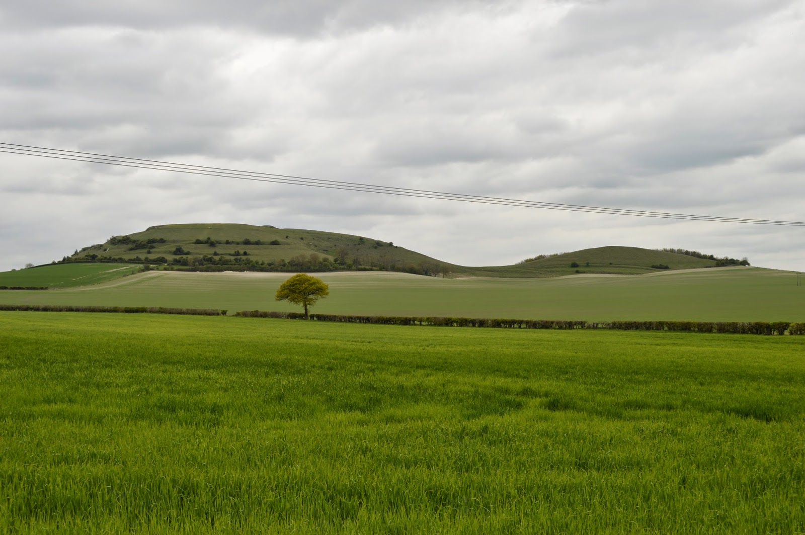
Cley Hill near Warminster.

Cley Hill from a distance.


View over Warminster from Cley Hill.

View from the main peak of Cley Hill looking towards Little Cley Hill.

Features on Cley Hill.

Cley Hill information board. 

Cradle Hill.

View from Cradle Hill. 

The Warminster Thing mural. 


Pictures: Wiltshire (May & July 2015).

If you find this post interesting please share it using the buttons below.


Thursday, 22 January 2015

A Grisly Place to Hang Out

On the Test Way footpath near the villages of Coombe and Inkpen in Berkshire, a gibbet can be seen sitting high on the hillside overlooking the surrounding countryside. The gibbet is known locally as Coombe Gibbet and it sits atop Inkpen hill - to be pedantic it actually sits upon a Bronze Age long barrow on the summit of the hill. The original gibbet was apparently erected in this very prominent location in 1676 to display the bodies of two convicted murderers, in an attempt to dissuade other people from committing such crimes.

The murderers in question were a pair of lovers known as George Broomham and Dorothy Newman. It is said that Broomham was married with a son and that Newman was a widow when the pair commenced an illicit relationship. Accounts vary, but it seems that as this illicit relationship progressed Broomham and Newman had cause to murder Broomham’s wife and son. This was probably because divorce in the 17th century was practically impossible, as it required a private Act of Parliament, so bumping off your unwanted wife was by far the more practical option. They committed this crime near the location of the gibbet, and unluckily for them, they were witnessed in the act.

During a trial at Winchester Assizes in February 1676, both Broomham and Newman were convicted of these murders and were sentenced to be publicly hanged. This execution took place in Winchester on 3rd March 1676. Following this hanging, the pair’s bodies were transported to the purpose built gibbet for public display, and their bodies were hung on the 6th March 1676.

The gibbet that stands today is not the original gibbet, but is believed to be the 7th gibbet to stand in this location and was erected in 1992. Previous gibbets erected in 1676, 1850, 1949, 1950, 1970 & 1979 seemed to have fallen prey to either the elements or persons of a vandalous nature.

The gibbet is not the only place of interest in the area, slightly further east along the Test Way footpath is Walbury Hill, which at 297 metres above sea level, is the highest point in South East England. Walbury Hill was once home to the Iron Age hill fort known as Walbury Camp, which was initially constructed circa 600 BC. At its peak the defensive earthworks of Walbury Camp would have protected an area of 80 acres, and the camp would have remained in use until the Roman era.

So if you ever walk the Test Way, be sure to look out for these two interesting features.

Coombe Gibbet visible in the distance.
The gibbet, sited on the long barrow at the summit of Inkpen Hill.
The gibbet.
Looking north from the gibbet into Berkshire.
Looking east from the gibbet towards Walbury Hill.

Pictures: Berkshire (January 2015).

If you find this post interesting please share it using the buttons below.

Friday, 15 August 2014

Gun End of Base?

If you live in the Salisbury area you will likely be familiar with the ancient site of Old Sarum. Old Sarum was originally an Iron Age hill fort, and following the Roman invasion of Great Britain it became the Roman settlement of Sorviodunum (43 AD – 410 AD). The site remained in use as a fortified settlement during the Saxon era and the Normans erected a motte and baily castle on the site (circa 1069).

A cathedral was built on the site between 1075 and 1092 and this was followed by the construction of a Royal Palace within the inner castle between 1130 – 1139. As the hill fort of Old Sarum was somewhat exposed to the elements, it was eventually decided to relocate the cathedral to a less exposed position, and in 1220 the construction of what would become New Sarum (Salisbury) Cathedral commenced. The general populous of Old Sarum followed the relocation of the cathedral, and Salisbury began to emerge as a settlement as the population moved themselves and their homes from Old Sarum. By 1240 the majority of the local population had abandoned Old Sarum in favour of Salisbury. Even though Old Sarum was now effectively population-less it still retained the right to send two members of parliament to the House of Commons. As such Old Sarum became known as one of the most famous “Rotten Boroughs” in the land, with wealthy people owning the land to ensure that they could become elected to parliament.

What most visitors to Old Sarum will miss however is a stone monument on the opposite side of the A345 to Old Sarum, which sits half way between Old Sarum and the Portway roundabout. The monument is marked on Ordnance Survey maps and on 1:25,000 scale maps and it is accompanied by the cryptic label “Gun End of Base”. The monument itself clearly explains its purpose and bears the following inscription  “In 1794 a line from this site to Beacon Hill was measured by Capt W Mudge of the Ordnance Survey as a base for the triangulation of Great Britain”.

It seems that in 1794 Captain William Mudge (1762 – 1820) of the Royal Artillery measured the distance between the site of the monument and nearby Beacon Hill, which is approximately 7 miles north east of Old Sarum and can be found between the A303 and the village of Bulford. This measurement apparently became the baseline from which the first definitive mapping survey of Great Britain began. The label “Gun End of Base” on today’s Ordnance Survey map apparently refers to the spot at which a cannon was buried vertically in the ground. It seems that the buried cannon would have been used as a point for Mudge to erect his theodolite on, prior to him making his measurements.

The question that springs to my mind is whether the label “Gun End of Base” appears on any other Ordnance Survey maps or if it is particular to Old Sarum. Time to get looking!


The monument to Captain William Mudge.


Old Sarum from a distance.

Information board showing an aerial view of Old Sarum.

Looking towards Old Sarum's motte.

The motte and its protective ditch.

Ruins inside the motte.


Looking out from the motte towards the ruins of the Old Sarum Cathedral.

New Sarum Cathedral can be seen in the distance.

A model showing what the motte may have once looked like.

Pictures, Wiltshire (August 2014).

If you find this post interesting please share it using the buttons below.

Friday, 8 August 2014

Uncovering an Unknown Building

Over the weekend of the 2nd and 3rd of August I was lucky enough to be able to spend some time helping a local archaeology team who are seeking to understand an unknown building that has been discovered in the hamlet of Bincknoll in Wiltshire.  

Bincknoll (pronounced Bynol) is a secluded rural hamlet that lies in the shadow of a former 11th Century (Norman) motte and bailey castle (Bincknoll Castle). The castle is believed to have been the seat of power for the local land owner of the period and today all that remains of this castle are some partial earthworks, which hint at what the site used to be. Bincknoll is also believed to have once been home to a medieval chapel and there is some documentary evidence that hints at its existence. However the location of this chapel has never been identified.

Finding the location of this medieval chapel recently became a possibility when a local home owner removed some trees from her lawn and uncovered what appeared to be a wall and some rubble from an previously unknown building. The wall that has been uncovered is made from chalk stone and has a west-east alignment, which interestingly does not align to any other local features (e.g. the road). Buildings with a west-east alignment are typical of Christian places of worship.  

With the possibility that the unknown building is medieval and may be the previously unlocated Bincknoll Chapel the excavations on site began.

The main aims of the excavation are to understand the extent of the building and its relation to the local landscape and to find features of the structure and contextual evidence that will enable it to be dated with some degree of confidence. Finding the original floor level of the building is a key objective, as the construction of the floor is likely to shed considerable light on the nature of the unknown building.

During my 2 days helping on the dig the wall and rubble field were uncovered to begin to understand the extent of the site and to enable the features to be charted and recorded. During these initial excavations a number of finds were made, which included:

  • Fragments of roof tiles.
  • Pig and sheep bones.
  • Pieces of mortar, and also what seems to be some mortar in situ on the outside wall of the building (this possibly shows that the outside of the building was once rendered?).
  • Oyster shells, which are apparently typical of Roman occupation in the area.
  • Flint cores and flint shards, which typically date from the Mesolithic era (10,000 - 4,000 years BC).
  • A possible piece of plaster with a thin surface of paint on it. If the building did have painted plaster it would hint towards it being a place a worship. 
  • Pieces of early medieval pottery. 
  • A return wall, enabling the team to be confident that they know what is the inside and what is the outside of the building.   

The dig will continue for a number of weeks, and once the team have planned and documented the exposed walls and rubble field they will slowly remove sections of the rubble field to explore the building. Painstakingly the team will remove layers from the site and eventually they may reach the original floor level. Hopefully during the dig the team will uncover suitable evidence to enable them to date the building and understand its former purpose, and maybe they might even be able to prove that it is actually the medieval Bincknoll Chapel.

The Bincknoll dig is being organized and managed by Broad Town Archaeology and the Wiltshire Archaeology Field Group, visit their Facebook pages to find out more!

Day 1 - The site ready for excavations to begin. The home owner had already uncovered some of the rubble field after removing some trees from the lawn. The wall of the building is on the right hand side of the picture.

Day 1 - The wall of the unknown building, which runs along a west to east alignment.

Day 1 - The other end of the site, marked out and ready for exploration. 

Day 1 - The wall and the rubble field are slowly uncovered. A trench is opened on what is believed to be the outside of the building to explore the depth of the wall.

Day 1 - At the end of the first day. The team continue to slowly uncover the rubble field and the trench outside the building is prepared for documentation.

Day 2 - Mrs J continues to expand the trench downwards. 

Day 2 - The wall and rubble field are cleaned ready for planning and documentation. 

Day 2 - Planning commences, objects of interest are marked using flags and a grid is used to enable the site to be sketched.

Day 2 - The hard job! The rubble field and wall have to be documented and planned before any rocks can be lifted to enable the team the excavate deeper. 

Day 2 - Some of the finds from Mrs J's trench, a flint core and some flint chippings - evidence of flint knapping on the site. 

Day 2 - Some of the finds from Mrs J's trench, mortar from the unknown building. 

Some of the remaining earth works at Bincknoll Castle.

The view from Bincknoll Castle, looking towards the M4.

Pictures, Wiltshire (August 2014).

If you find this post interesting please share it using the buttons below.

Monday, 21 July 2014

The Lambton Worm

Anyone who has ever visited the Sunderland area will no-doubt have seen the monument pictured below, which stands proud upon Penshaw Hill, and dominates the local landscape. The monument is known as the Penshaw Monument and it was built in 1844 as a half-sized replica of the Temple of Hephaestus in Athens. The monument measures in at 30 metres in length, 16 metres in width and 20 metres in height, and has columns that are 2 metres in diameter. The formal name of the monument is The Earl of Durham's Monument and it was built in dedication to John Lambton (1792–1840) who was the 1st Earl of Durham and the first Governor of the Province of Canada.

The Lambton family are associated with an interesting local legend, the legend of the Lambton Worm.

The legend surrounds another John Lambton who skipped church one Sunday to go fishing in the River Wear. The fishing trip was generally unsuccessful, but Lambton eventually catches an eel like creature, which he disposes of in a nearby well.  Forgetting about this creature, Lambton grows up and eventually heads overseas to join the crusades (putting the legend somewhere in the 12th Century). Over the years the creature grows extremely large and begins to terrorise local villagers, coiling itself seven times around a local hill.

Eventually the worm makes its way to Lambton Castle, where the Lord (John Lambton's father) is able to sedate the worm, via a daily ritual of offering it copious quantities of milk. A number of attempts are made by local villagers and knights to kill the worm, however all these attempts fail, as any parts of the worm that are cut off seem to re-attach themselves to the worm, healing it.

After seven years, Lambton returns from the crusades and finds that his father's estate is almost bankrupt because of the worm and the costly demands of keeping it satisfied. In response to this, Lambton resolves to destroy the worm, but first he seeks guidance from a witch near Durham. The witch advises Lambton to cover his armor in spikes and fight the worm in the River Wear, where it spends its days wrapped around a rock. The witch also advises Lambton that after killing the worm he must then kill the first living thing he sees, or else his family will be cursed not to die peacefully in their beds for nine generations. Deciding to follow the witch’s advice, Lambton arranges with his father that he will sound a horn three times once the worm has been killed. The plan being that once the signal is heard, Lambton’s father would release Lambton’s dog, which would run to Lambton to be killed, thus preventing the curse from being enacted.

Lambton does battle with the worm at the river and when the worm tries to curl itself around him it hurts itself on the spikes on his armor. As Lambton cuts pieces off of the worm, the river washes them away. Unable to heal itself, the worm finally succumbs and Lambton sounds his horn in victory. In the excitement of victory, Lambton’s father forgets to release the dog and instead rushes to congratulate his son. Lambton, cannot bring himself to kill his father (as the first living thing that he sees) and as a result nine generations of the Lambton family are duly cursed.

The local hill that the worm coils itself around seven times is often said to be either Penshaw Hill or sometimes it is the much less impressive Worm Hill in Fatfield. It's easy to see why Penshaw hill might fit the bill, as it is said that the hill that the worm coiled itself around was scarred by the worm's presence. Penshaw Hill is the only triple rampart Iron Age hill fort known to exist in the north of England and it is easy to see how the remains of these ramparts could be interpreted as marks left by the coiling worm.

The legend of the Lambton Worm is a staple of local folklore and has inspired at least one movie, Ken Russell’s The Lair of the White Worm.

The Penshaw Monument.


Dedication on the Penshaw Monument.
Information board.
The Penshaw Monument at a distance.
The Penshaw Monument, visible from the roof of Durham Cathedral.
Worm Hill in Fatfield - natural or man-made structure?
Pictures, County Durham (June 2014).

If you find this post interesting please share it using the buttons below.