“Random encounters with the unusual” is a repository for the oddities that me and Mrs J have encountered on our travels, which we find interesting or amusing in some way. Have a look, maybe you will find something interesting or amusing herein.

Showing posts with label Oxfordshire. Show all posts

Thursday, 14 July 2016

The Blowing Stone

The Blowing Stone is a sarsen stone that resides outside Blowing Stone Cottages, at the base of Blowingstone Hill, just to the south of the B4507 near Kingston Lisle in Oxfordshire.

The sarsen is around 3ft tall and is perforated by a number of holes, which were possibly created by long vanished tree roots. It is said that one of the holes in the stone, if blown into in the correct manner, turns the stone into a form of trumpet and produces a loud booming sound that can be heard for several miles around. According to legend the Blowing Stone was originally located on Kingstone Down, a few miles to the south west of its present location, and it was here that King Alfred made use of the stone’s trumpet-like effect. King Alfred apparently used the Blowing Stone to rally his Saxon armies in preparation for his battle against the Vikings at the Battle of Ashdown. But like all good legends, it is highly unlikely to be true!

The Blowing Stone seems to have been first documented in 1761 and it is believed that the stone was brought down from the ridgeway in the mid-18th century by either a local blacksmith or a local landowning family, who placed the stone in its present position outside the cottages. In 1811 the Blowing Stone Cottages were in fact the Blowing Stone Inn, and the landlord of the time would apparently amuse his customers by making the stone bellow for a small fee. It seems that using the stone to generate an income may have continued for a good number of years. The “Getty Images” website hosts a picture of the stone dating from c1860-c1922 and claims to show an enterprising young boy on hand to charge tourists who try to blow the stone.

The Blowing Stone has also featured in fiction, being referred to in Thomas Hughes’ (1822 – 1896) novel “Tom Brown's Schooldays” which was published in 1857. In the novel the stone is referred to as the “Blawing Stwun”.

The idea of a Blowing Stone is not just limited to Oxfordshire. As the “Legendary Dartmoor” website suggests, Devon is also home to a tradition of a Blowing Stone. Unlike the Kingston Lisle sarsen, which was used as an instrument itself, the Devon Blowing Stone was instead used to amplify the sound of a trumpeter’s horn. The Devon Blowing Stone is described as a flat slab of granite with a concave hollow in it. The trumpeter was said to place the end of his horn into the hollow and then blow his trumpet. The Blowing Stone would then amplify the sound of the trumpet allowing it to be heard far and wide.

So if you are ever passing the Blowing Stone at Kingston Lisle why not stop and try blowing the stone? Legend does suggests that any person who is capable of making the Blowing Stone sound a note which can be heard atop of the nearby White Horse Hill at Uffington will be a future King of England. So it is worth an attempt, as long as you don’t mind pursing your lips against a dirty old piece of rock where countless other lips have been pursed before!

The Blowing Stone Cottages.


The Blowing Stone.


The new Blowing Stone Inn at nearby Kingston Lisle.


Kingston Lisle Church.

Pictures: Oxfordshire (June 2016).

If you find this post interesting please share it using the buttons below.

Tuesday, 5 July 2016

The Headington Shark

I first saw the Headington Shark in March 1994 on the front cover of Fortean Times, and in June this year I finally got to see it in the flesh.

The Headington Shark “crash landed” head first in to the roof of 2 New High Street, Headington, Oxford early on the morning of Saturday 9th August 1986, 41 years to the day that the atomic bomb was dropped on the Japanese city of Nagasaki.

The 299kg, 7.6m (25ft) long painted fibreglass shark was the brain child of the property owner Bill Heine and sculptor John Buckley. Known formally us “Untitled 1986”,  when Heine was asked what the purpose of the shark was, his reply was apparently: "The shark was to express someone feeling totally impotent and ripping a hole in their roof out of a sense of impotence and anger and desperation... It is saying something about CND, nuclear power, Chernobyl and Nagasaki"

After its installation the shark became a local topic of controversy and a 6 year battle commenced between Heine and Oxford City Council, who wanted the shark removed. The Council first tried to have the shark removed on the grounds of health & safety. However, following an inspection, the structure was declared safe and secure. So the council pursued the line that the shark should be removed because planning permission had not been granted, and because of the precedent that it might set. If the shark was allowed to stay everyone might want one on their roof! Somewhat expectedly the council rejected Heine’s retrospective application for planning permission.

Undeterred, Heine and local residents battled to keep the shark and in 1992 the case was eventually escalated to central government. Peter Macdonald, a minister in the Department of the Environment, was asked to rule on the case. Heine's book "The Hunting of the Shark" outlines Macdonald's verdict:

"Into this archetypal urban setting crashes (almost literally) the Shark. The contrast between the object and its setting is quite deliberate. In this sense, the work is specific to its setting, and it would "read" quite differently in the context of, say, the foyer to an arts centre in Gloucester Green. 


It is (as the Council say) incongruous, and that incongruity is quite consciously sought by the artist. It is, indeed, out of harmony with its surrounds. It is that lack of harmony, that sense of being “out of place”, to which the Council objects, and which it equates with demonstrable harm to visual amenity. It is the very same feature which appeals to many of the Shark’s supporters, and which has made it an urban landmark… An “incongruous” object can become accepted as a landmark in some cases becoming well-known, even well-loved, in the process. Something of this sort seems to have happened, for many people, to the Shark.

There is a real sense in which permitting the Shark to remain is the “risky” option, the safe and easy thing to do being to remove it. However, I cannot believe that the purpose of planning control is to enforce a boring and mediocre uniformity to the built environment. Any system of control must make some small space for the dynamic, the unexpected and the downright quirky or we shall all be the poorer for it. I believe that this is one case where a little vision and imagination is appropriate, and I recommend that the Headington shark be allowed to remain."

So whilst the government is often accused of being bureaucratic, it seems that common sense and imagination can sometimes prevail!

The Headington Shark.


The cover of Fortean Times #73.

Pictures: Oxfordshire (June 2016).

If you find this post interesting please share it using the buttons below.

Tuesday, 28 April 2015

The Wheatley Pyramid

The pyramidal structure pictured below can be found in the Oxfordshire village of Wheatley at the junctions of Church Road and Holloway Road. The pyramid is built from locally quarried limestone and is about 1.8m square at the base and around 2.5m high. The only visible opening in the structure is a sturdy wooden door in the front that is secured by a padlock.   The pyramid was built in 1834 and is not some oddly located mausoleum, but is instead the old village lock-up.

In the 19th Century most villages had lock-ups which enabled local criminals to be detained for short periods prior to them being taken away to the nearby court to be dealt with. Village lock-ups were routinely used until around 1839, after which each county was allowed to create local paid police forces bringing with them police stations and holding cells. This creation of local police forces led to the decline and neglect of these unique structures. A number of village lock-ups still survive however and can often be found hidden in plain sight.

Wheatley lock-up.


Here are two more less impressive examples of lock-ups, the first is in Lyme Regis in Dorset and can be found in what is today the Guild Hall. The second is in Devizes in Wiltshire and is hidden at the rear of the Town Hall.

Lyme Regis, Dorset

Lyme Regis Guild Hall, the site of the old lock-up.

The entrance to the old lock-up.


Devizes, Wiltshire


The old lock-up, hidden at the rear of the town hall. 


So keep an eye out for local lock-ups hidden in plain sight! And I will post more as I find them.

Pictures: Oxfordshire (April 2015), Dorset (September 2013) and Wiltshire (August 2014).

If you find this post interesting please share it using the buttons below.

Tuesday, 21 October 2014

The Home of Halley

The house shown below is on New College Lane in Oxford and is adorned by a small wooden plaque which reads: Edmond Halley Savilian Professor of Geometry 1703 - 1742 lived and had his observatory in this house.

It seems that the English astronomer and mathematician Edmond Halley (1656-1742) spent a significant period of his life in Oxford, firstly as a student at Oxford University and latterly as a professor.  Halley is most famously known for calculating the orbit of the comet that was named after him.

Halley spent some of his career calculating the orbits of 24 comets that had been observed between 1337 and 1698. During these calculations he postulated that three of the observed comets which appeared in 1531, 1607, and 1682 were likely to be the same object returning to the solar system time and again. Based on his calculations Halley postulated that the comet would return in 1758 and on the 25 December 1758 (16 years after Halley’s death) the comet did return. The comet was posthumously named after Halley.

Halley’s Comet is known as a “short period comet” and is the only comet of this type to be visible from Earth with the naked eye. Halley’s Comet is also the only known short period comet that can appear twice within a human lifetime, as its periodicity is around the 75 year mark. Because Halley’s Comet is visible to the naked eye its appearance over the Earth has often been recorded within human history.

The first confirmed historical account of Halley’s Comet dates from 240 BC when its appearance was recorded in a Chinese chronicle. Babylonian records from 164 BC and 87 BC also record visits by the comet. Chinese astronomers recorded the comet’s visit to Earth in 12 BC, and some propose that this visit may have inspired the biblical story of the Star of Bethlehem, as the appearance of the comet was only a few years distant from when Jesus is believed to have been born (circa 7 to 2 years BC).  The comet continued to be observed and recorded over the years and the next most notable appearance was in 1066 when the comet was most famously recorded in the Bayeux Tapestry which chronicled the Battle of Hastings and the death of King Harold II of England.

Calculating the return of the comet was not Halley’s only accomplishment, during his illustrious career he is also known for a number of other achievements. Between 1676 and 1678 Halley recorded the celestial longitudes and latitudes of 341 stars in the southern hemisphere. In 1691, Halley built a diving bell, and with five companions he dived to a depth of 18m in the River Thames where they are reported to have remained for over 90 minutes. Halley further refined his diving bell design and was eventually able to execute dives of up to 4 hours in duration. Halley also pioneered a basic model of a magnetic compass, and established the link between barometric pressure and height above sea level.

Not all of Halley’s work and theories were sound however. Halley was a “hollow-Earther” and in 1692 he proposed the idea that the Earth was hollow and comprised of an outer shell that was 800km thick with two further inner shells and a core at the centre. He proposed that each shell was separated by an atmosphere and that each shell had its own magnetic poles and that they all rotated at different speeds (potentially explaining anomalous compass readings). In Halley’s model of the Earth each shell had its own atmosphere, and he proposed that it was the escape of this gas that caused the Aurora Borealis. Halley also suggest that each shell was illuminated and may also possibly harbour life.

In 1694 Halley proposed that the biblical story of Noah's flood might be an early account of the result of a comet impacting the Earth. This was an idea that was not well received by The Royal Society!

1720 saw Halley participating in the first known attempt to scientifically date Stonehenge. The working assumption being that Stonehenge had been laid out using a magnetic compass and extant magnetic records where used to try to calculate a construction date. Based on this method the earliest proposed date for the construction of Stonehenge was estimated as 460 BC, which as we know today is somewhat wrong, with the current accepted date being somewhere between 3,000 and 2,000 years BC.

So next time you visit Oxford look out for Halley's house, and if you happen to still be alive in 2061 keep an eye on the sky, you may get to see his comet!

New College Lane, Oxford.

The house where Halley lived. 

The memorial to Halley's time in residence.

New College Lane also features this interesting foot bridge that was erected in 1914 to link two buildings of Hertford College. Some say that this bridge is reminiscent of the Venetian Bridge of Sighs. 

Pictures, Oxfordshire (October 2014).

If you find this post interesting please share it using the buttons below.

Sunday, 12 October 2014

Oxford Curiosities

During a recent scamper around the free museums of Oxford, I spotted two items on display that piqued my curiosity. Here is what I found:

The Dangers of Metal Wallpaper

The below two pictures show an Electrostatic Lightning House on display in the Oxford Museum of the History of Science, which was manufactured by W. & S. Jones, London circa 1830.

The Electrostatic Lightning House is a small wooden model of a house, which is home to three women (who seem to be made of paper), who are attached by small wires to a lightning conductor on the roof of the house. The model seems to be a representation of an event that occurred in the 18th century.  The occupants of a property were injured when it was struck by lightning and the metal in the wallpaper of the property brought the electricity into contact with them. The label accompanying the model explains:

Lightning House

Unique model replicating an actual event described in the 18th century: the occupants of a house received severe shocks from the metal patterns in their wallpaper as a lightning bolt coursed through the house to earth. In the model, the figures are placed in front of small spark-gaps made by wires in the walls of the house. They were knocked over by the sparks when a Leyden jar was discharged through wires. 

Sadly a search of the Internet revealed no further information on the curious events that are depicted by the model. But it stands without saying, be careful if you have metal wallpaper!


The Bottled Witch

The next curiosity was seen in the Pitt Rivers Museum in Oxford. The diverse collection that forms the Pitt Rivers Museum includes a display of magical items. One of these items is a small silvered bottle that apparently contains a witch. The label that accompanies the bottle reads:

EUROPE, ENGLAND, SUSSEX, HOVE.
Silvered and stoppered bottle said to contain a witch, obtained about 1915 from an old lady living in a village near Hove, Sussex. She remarked “... and they do say there be a witch in it and if you let un out there it be a peak o' trouble.”
Donated by Miss M. A. Murray. 1926.6.1

Here's to wondering what the bottle really does contain!


Pictures, Oxfordshire (October 2014).

If you find this post interesting please share it using the buttons below.

Thursday, 23 January 2014

The Wonders of Uffington

In this blog I have previously mentioned the Oxfordshire village of Uffington as the home of the Uffington White Horse, which is thought to be the oldest white horse in Britain. It was not until I recently visited Uffington however that I became aware of some of the other wonders that the local landscape has to offer.

The white horse lives next to Uffington Castle. Uffington Castle is an Iron Age bank and ditch style hill fort which encloses around 8 acres of land and commands extensive views over the local countryside, as can be seen in the below photos.

Uffington Castle's earthworks. 
Uffington Castle's earthworks and extensive views. 
Information board.

Directly below the white horse is a small chalk hillock that has a seemingly artificial flat top. This hillock is known as Dragon Hill. This hill is linked to the legend of King George and the dragon. The legend claims that the summit of the hill is where Saint George slew the dragon, and that the bare patch of chalk that can be seen is where the dragon’s blood spilled (and hence no grass will now grow there).

It has also been suggested that Dragon Hill may have been used for Iron Age rituals that were associated with the white horse.

Looking from above the horses' head down towards Dragon Hill.
Dragon Hill. 
Looking back up towards the white horse from Dragon Hill.

The other local feature, that is about a mile walk along the Ridgeway from Uffington Castle, is the Neolithic long barrow which is known as Wayland’s Smithy.

This tomb dates from around 3700 BC and is about 56m long by 13m wide. When the tomb was excavated in the 1960’s it was found to contain the remains of 14 people, who seem to have been de-fleshed before burial.

The name of the tomb derives from its association by the Saxons with the Germanic god Wayland (also known as Wolund) who was a smith. The Saxons began to live in the area around 4000 years after the tomb was built and the Saxon association of the tomb with Wayland the Smith gave rise to an interesting legend. Apparently if a traveller had a horse that had lost a shoe, leaving the horse and a silver coin (as payment) at the tomb overnight would result in the horse being re-shod by morning.

Information board.
Side view of the long barrow.
Front view of the long barrow.
The entrance.
Looking from the back to the front of the long barrow.
Even though the long barrow of Wayland’s Smithy is around 5700 years old it seems that practice of using long barrows as tombs has not died out entirely. The village of All Cannings, near Devizes in Wiltshire, will soon be home to a new long barrow which is currently under construction. Once completed, paying customers will be able to book their place in eternity in the long barrow - a method of burial that was once reserved only for the social elite of ancient Britain (December 2013 news article, January 2014 news article).

Pictures, Oxfordshire (December 2013).

If you find this post interesting please share it using the buttons below.

Friday, 4 October 2013

Completing the Armchair Tour of Britain's Hill Figures

Following on from my "Armchair Tour of Britain's White Horses" in my last blog post, I have again used the power of Google Maps to explore some of the other (non-equine) hill figures that can be found dotted around our countryside. The hill figures found below are listed by approximate age, with the oldest first.

The Cerne Abbas Giant (Dorset)

The Cerne Abbas Giant is perhaps the most famous of all British hill figures, possibly because he sports a rather large erection! The giant (and his protruding member) can be found north-east of the village of Cerne Abbas carved into the side of Giant Hill (which is also known as Trendle Hill).

Although most people assume that the giant is ancient, there is little firm evidence to provide an accurate estimation of the construction date of the giant. The earliest known documentary evidence mentioning the giant is said to date from the late 1600's.

The giant stands 55 m high by 51 m wide and some archaeological work suggests that the giant once had a cloak, net or animal skin draped over his outstretched left arm, a feature that has been lost over time.
Location (50.81368, -2.474724)
The Wilmington Long Man (East Sussex)

The Wilmington Long Man is a very well-known hill figure that can be found to the south of the village of Wilmington and to the south-east of the village of Milton Street (just north of the South Downs Way). The Wilmington Long Man is cut into the steep slopes of Windover Hill and is measured at 69 m tall. He cuts a distinctive figure because he holds a long “pole” in each hand.

The Wilmington Long Man has over the years been known by a number of different names, and is sometimes referred to as the Wilmington Giant, or as the Green Man. It is believed that the Long Man was at some point during his life only present as an indentation in the grass and hence he was labeled as the Green Man.

The creation date of the Long Man is unknown. It seems that for a long while he was believed to have dated from the Iron Age or Neolithic period, but now there is some evidence to suggest that he may be a much more modern creation, perhaps dating from the 16th or 17th Century. It seems that the earliest piece of documentary evidence depicting the Long Man dates from around 1710.

During World War II the Wilmington Long Man was disguised to prevent him aiding German Pilots, this was achieved by painting him green.
Location (50.81007, 0.188065)


The Whiteleaf Cross (Buckinghamshire)

The Whiteleaf Cross is a chalk carving comprising of a large triangular base with a cross perched on the pinnacle. The Whiteleaf Cross can be found to the north-east of Princes Risborough, and just to the side of Peters Lane.

The precise date and origin of the cross are not known and there seem to be a number of theories as to what the cross is supposed to represent or commemorate. The earliest documented mention of the cross is reportedly from 1742, but how long the cross had been in existence prior to this mention seems to be unknown.
Location (51.728683, -0.811992)


The Watlington White Mark (Oxfordshire)

The Watlington White Mark lies south-east of the village of Watlington, just to the south-east of where Hill Road intersects The Ridgeway.

The white mark was apparently designed by a local man who one day decided that the local church (when viewed from his home) would look more impressive if it had a spire! So in 1764 to provide the church with a spire he cut the white mark into Watlington Hill. The Watlington White Mark is measured at 11 m wide (at the base) and 82 m in length.
Location (51.639039,-0.989854)


The Strichen Stag (Aberdeenshire)

The Strichen Stag is a hill figure that has been created from local white quartz rocks (as opposed to the more typical chalk constructions). The stag lives north-east of the village of Strichen, on Mormond Hill, and can be found to the east of the Strichen White Horse.

Interestingly even though the stag is only a couple of miles from the white horse, there seems to be a band of gray on Google Maps (presumably cloud) that makes the stag hard to see. But it's head can just be made out by a keen eye.

The Strichen Stag was constructed in 1870 and is larger than the Strichen White Horse, measuring around 73 m in length.
Location (57.602141,-2.025503)


The Wye Crown (Kent)

The Wye Crown lies on the Downs to the east of the village of Wye (to the north-east of Coldharbour Lane). This crown is believed to have been carved in 1902 to commemorate the coronation of Edward VII.
Location (51.18124, 0.962306)


The Compton Chamberlayne "Australia" (Wiltshire)

Perhaps the most unusual of the chalk figures included in this post, The Compton Chamberlayne “Australia” is an outline map of Australia marked into the Wiltshire countryside. This chalk map can be found south-east of the village of Compton Chamberlayne, and only a short distance from the nearby Fovant Badges.

Presumably the carving dates from around World War I, when there were thousands of Australian and Canadian troops encamped in the vicinity awaiting transport to the war in France. The local graveyard in Compton Chamberlayne contains the graves of around 20 Australian soldiers who are believed to have died of influenza while awaiting transportation to France.
Location (51.061809, -1.940021)


The Bulford Kiwi (Wiltshire)

The Bulford Kiwi can be found just east of Gallipoli Road in the town of Bulford. The Kiwi is carved into Beacon Hill which overlooks the town, and is very hard to discern from the road as you drive through the town.

The Kiwi was created by soldiers from New Zealand whilst they were awaiting repatriation after the end of World War I. The Kiwi was cut in early 1919 by the Canterbury and Otago Engineers Battalions, and it seems that the creation of the Kiwi may have been used as a way to keep the troops busy whilst they awaited the trip home.

The Kiwi is a large carving and covers approximately 1.5 acres.
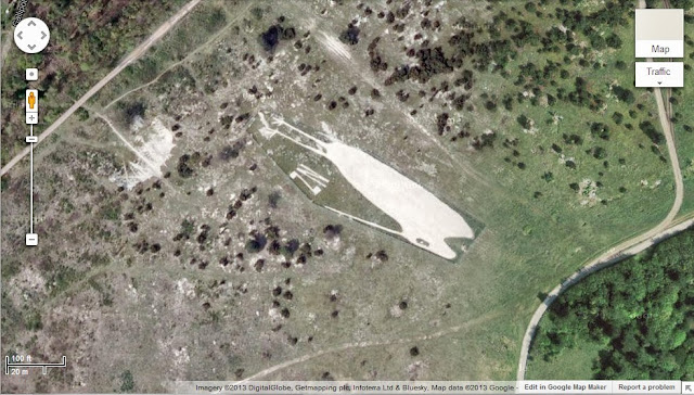
Location (51.194174, -1.715252)


The Fovant Badges (Wiltshire)

On the A30 near to the village of Compton Chamberlayne and south-east of the village of Fovant, a series of chalk military badges can be found which are known as The Fovant Badges.

Similarly to the Compton Chamberlayne “Australia”, The Fovant Badges were initially created by soldiers who were stationed in the area waiting to go to France in 1916 to fight in World War I, and further badges were added over time. At one point there were twenty badges, but today only eight of these originals remain (plus a ninth, crudely cut YMCA badge).
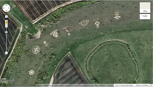
Location (51.053966, -1.978615)


The Lamb Down Badge (Wiltshire)

The Lamb Down Badge is located east of the village of Codford and to the north of the A36. The badge is the emblem of the Australian Commonwealth Military Forces and is known as the “Rising Sun Badge”. The badge was cut in 1916/1917 by Australian troops who were based in the area.

The badge measures approximately 175 ft by 150 ft.
Location (51.153785, -2.024468)


The Shoreham Memorial Cross (Kent)

The Shoreham Memorial Cross can be found north-west of Shoreham (Kent) on the edge of Meenfield Wood. The chalk cross was constructed in 1920 and was designed as a memorial to local men who died during World War I.
Location (51.336613, 0.17315)


The Lenham Memorial Cross (Kent)

The Lenham Memorial Cross can be found to the north-east of the village of Lenham, carved into the slope of the North Downs (near The Pilgrim’s Way/North Downs Way). As its name suggests the cross is a war memorial, which was constructed in 1922 to originally commemorate those who died in World War I. The cross is approximately 200 ft across and was apparently filled in during World War II, to prevent it being used as a navigational aid by attacking German aircraft.
Location (51.242391, 0.729064)


The Whipsnade White Lion (Bedfordshire)

The Whipsnade White Lion lives just to the west of Whipsnade wildlife park, between Dunstable Road (B4506) and Escarpment Avenue. The lion is a large beast, measuring in at around 500 ft in length. The lion was constructed in 1933, and like many other chalk figures it was covered during WWII to prevent it being of use to German pilots.
Location (51.848657, -0.554436)


The Brighton White Hawk (East Sussex)

The Brighton White Hawk can be found in the Whitehawk area of Brighton, to the east of town, and just east of the Whitehawk football ground. The White Hawk, which is now rather faded, can be found by a keen eye between the White Hawk football ground and the golf course.

It seems that the hawk was created in late 2001.
Location (50.82113, -0.09321)


The fading Brighton White Hawk completes the list of the hill figures that I was able to locate using the power of Google Maps. It seems that Britain has been home to a large number of other hill figures over the years, however many seem to have been lost due to a lack of maintenance or via other destructive influences. If I find out about any more they will be posted here!

Pictures, Google Maps (September 2013).

If you find this post interesting please share it using the buttons below.