“Random encounters with the unusual” is a repository for the oddities that me and Mrs J have encountered on our travels, which we find interesting or amusing in some way. Have a look, maybe you will find something interesting or amusing herein.

Saturday, 23 November 2013

England's "Forgotten" Empress

I currently live in a town called Ludgershall on the Wiltshire/Hampshire border. Ludgershall today is a fairly unremarkable army town, but it has a recorded history that stretches back to the Domesday Book (1086) and beyond. At the time of the Domesday Book the town was referred to as Litlegarsele, which apparently translates to "small grazing area". For the majority of Ludgershall's history it has had a castle of which today only a series of earthworks and a ruin remain. Ludgershall castle is believed to have been built in the late 11th century by Edward of Salisbury and became a royal property around 1100. Over the years the castle was improved and in 1210 King John (the King who famously lost his crown jewels in The Wash) repaired and improved the castle and adopted it as a hunting lodge. This hunting lodge was subsequently used by his son, King Henry III. The castle remained in use as a hunting lodge and was frequented by royal visitors until it eventually fell into disrepair in the 15th Century.

It was whilst reading about the history of the castle I become aware of the tale of England's “forgotten” Empress, Empress Matilda.

King Henry I of England (1068 - 1135) had two legitimate children, William Adelin and Matilda (also known as Maude). William died at 17 years old (in 1120), which left Matilda as King Henry's only legitimate heir. Matilda was betrothed and eventually married off to Henry V (the Holy Roman Emperor), which resulted in her becoming the Holy Roman Empress.

When King Henry I died in 1135 a power struggle for the English crown ensued between Stephen of Blois (King Henry I's nephew) and Matilda. This civil war, known as the "Anarchy”, lasted between 1135 and 1153. After the death of King Henry I, Stephen immediately took power, and Matilda led a rebel movement to take the crown for herself. In 1141 Matilda's forces managed to take King Stephen prisoner at the battle of Lincoln, and she effectively deposed him from rule. This situation only lasted a few months however and whilst trying to be formally crowned in London in June 1141 she was evicted from the city by the populous. Worse still for Matilda in September 1141 the army of imprisoned King Stephen defeated Matilda's army who were besieging them at Winchester. Following this rout Matilda had to flee to Gloucester and en-route she sought refuge at Ludgershall castle. Eventually Matilda had to release King Stephen in exchange for prisoners taken in the rout at Winchester and following further defeats Matilda eventually fled back to the continent. However, after the death of King Stephen's son (Eustace), Matilda's first son (Henry) become recognised as King Stephen's heir and eventually became King Henry II of England.

So even though Matilda is often forgotten from the list of British Monarchs, she was effectively England's first female ruler few a months in 1141.

Remains of the castle's Royal Apartments.


Looking along a ditch.
View from the outer bank, looking North. 
Explanation of the layout of the site.
Artist impression of the Royal Apartments.

Pictures, Wiltshire (November 2013).

If you find this post interesting please share it using the buttons below.

Friday, 15 November 2013

Sin City's Mormon Fort

The Mormon faith has always held some Fortean interest for me, especially the story behind how the religion was created by the enigmatic Joseph Smith (1805 – 1844). In his early life Smith supplemented his income by searching for lost items and buried treasure, using seer stones as his method of detection. In his twenties Smith claimed to have been visited by an angel who revealed to him the location of a buried book made from golden plates (amongst other artifacts). Smith was charged by the angel not to show the plates to anyone and to translate them. Smith used a seer stone to translate the golden plates and he subsequently published the Book of Mormon, which formed the basis of the Mormon faith. Unfortunately for the world, after completing his work Smith was said to have given the plates back to the angel and as such the golden plates were lost to history.

Today Las Vegas is known as a city where gambling, drinking and debauchery are the order of the day and I was surprised to find that this concrete metropolis was home to a 19th Century Mormon fort. It seems that the oasis that is the Las Vegas Valley was first discovered by modern day Americans in the early 19th Century, when traders trying to develop trade routes west across the country to Los Angeles happened upon it. As the Las Vegas Valley had a plentiful supply of water, the traders decided that it was good place to stop off and resupply on the journey west.

The discovery of this oasis brought the valley to the attention of others and in 1855 a group of 30 Mormon missionaries from Salt Lake City travelled to Las Vegas with a view to developing a permanent settlement there. This Mormon settlement primarily comprised of an adobe fort which was built next to a nearby creek. The fort was fairly substantial and was built as a square with walls of 46m in length and 4.3m in height.

This fort can still be found today, but the fort is now mostly a reconstruction. The original fort was built from bricks made of earth, most of which have long since weathered away.

The fort.


A 19th Century wagon.
The creek that made life at the fort sustainable.
Sorting soil to make bricks for the fort's walls.
Creating the bricks.

Pictures, Las Vegas (October 2013).

If you find this post interesting please share it using the buttons below.

Thursday, 7 November 2013

Notable Nuggets

Whilst on a recent trip to Las Vegas I happened to visit the Golden Nugget Casino in the Freemont Street area of the city and was surprised to find a rather large gold nugget on display inside. The nugget in question is called The Hand of Faith and claims to be the largest gold nugget on public display in the world, which I assumed to be true as it weighs 27 kg. The Hand of Faith was found in 1980 by a man from Wedderburn in Victoria (Australia) using a metal detector. The caption in the display explains:

"This magnificent gold nugget, the largest on public display in the world was discovered using a metal detector, lying six inches below the surface in a vertical position. It weighs a massive 875 troy ounces, (61 pounds, 11 ounces av.)

A man, who has chosen to remain anonymous, his wife, and four young children were prospecting behind their modest trailer home when they made this spectacular find."

The size of this nugget got me wondering if it was truly a giant of the nugget world or if larger nuggets have been found. It seems that The Hand of Faith is actually fairly small when compared to some of the giant nuggets that have been found:

- The Welcome Stranger Nugget was found at Moliagul in Victoria (Australia) in 1869 and weighed in at 2,520 troy ounces (78 kg).

- The Welcome Nugget was found at Bakery Hill in Ballarat (Australia) in 1858 and weighed in at 2,218 troy ounces (69 kg).

- The Canaã Nugget was found at the Serra Pelada Mine in the State of Para (Brazil) in 1983 and weighed in at 2,145 troy ounces (67 kg). However, there does seem to be some suggestion that this nugget was actually part of a larger nugget weighing 5,291 troy ounces (165 kg) that broke during excavations.

It seems that the Canaã nugget is currently on display in the Gold Room of the Banco Central Museum in Brazil, which seemingly makes the Golden Nugget's claim that The Hand of Faith is the largest nugget on public display false!


The Hand of Faith
The Hand of Faith
Pictures, Las Vegas (October 2013).

If you find this post interesting please share it using the buttons below.

Tuesday, 29 October 2013

Shopping for the Zombie Apocalypse

Over the last decade the idea of mankind being exterminated by an uprising of hungry Zombies has become a regular focus of TV shows and feature films with some notable productions being: The Walking Dead (2010 – present); World War Z (2013); the REC series (2007 – 2012); the Resident Evil series (2002 – 2012); Zombieland (2009); 28 Weeks Later (2007); Land of the Dead (2005); Shaun of the Dead (2004); Dawn of the Dead (2004); and 28 Days Later (2002).

Given this on-going reminder of the possible perils of a Zombie uprising it is no wonder that some people may be concerned enough to want to prepare for a potential zombie apocalypse. Luckily for those that do want to be ready there is now a dedicated shop for all your Zombie apocalypse needs. The Las Vegas Zombie Apocalypse Store (3420 Spring Mountain Rd, Las Vegas ) carries a selection of goods to help you survive the rise of the Zombie horde, from weapons to survival equipment and even a Zombie survival guide.

So if the impending rise of the Zombie horde keeps you awake at night it is time to get shopping!


Pictures, Las Vegas (October 2013).

If you find this post interesting please share it using the buttons below.

Friday, 11 October 2013

The Hill Fort at Ham Hill

Just west of Yeovil in Somerset on Ham Hill a large Iron Age hill fort and a set of standing stones await the passing visitor.

The hill fort is an impressive construction in the double bank and ditch design, which has 3 miles of ramparts (which rise in places to 12 m in height). The ramparts defend an approximate area of 210 acres and the hill fort sits at around 120 m above sea level, with commanding views of the surrounding landscape.

Archaeological evidence points to the hill fort having been occupied for a significant portion of its history. It is first believed to have been occupied in the 7th Century BC and to also have been used during the Roman era (approx. 43AD – 400AD). It is uncertain whether the site was occupied during the Saxon era (approx. 400AD – 1065AD), but it was certainly in use during the Medieval era (approx. 1066AD – 1484AD). Today the hill fort is occupied by a Visitor Centre and a Public House, making Ham Hill perhaps the only hill fort in the country with its own pub!

The hill fort has produced numerous archaeological finds over the years that have been used to date the periods of occupation, including: sling stones, bronze armor scales, chariot parts, iron currency bars, gold and silver coins, cremations and burials.

The other notable feature at Ham Hill is the circle of standing stones, which are Hamstone. Ham Hill is well known for its quarry and the honey coloured stone (Hamstone) that is produces. Hamstone is used as a building material and has been used for a number of impressive properties in the area, including nearby Montacute House. It seems that the standing stones are a modern creation which were erected in 2000 to commemorate all of the workers who have quarried stone at Ham Hill over the centuries.

So if you are looking to visit a hill fort, see a set of standing stones and have a pint, then Ham Hill is the place to go.
The ramparts.
The ramparts and visitor centre. 
More ramparts.
Yet more ramparts, with standing stones in the distance.
The stones.
The stones from above.
Hamstone close up.
Views from the hill fort.
Ham Hill war memorial.

Pictures, Somerset (September 2013).

If you find this post interesting please share it using the buttons below.

Friday, 4 October 2013

Completing the Armchair Tour of Britain's Hill Figures

Following on from my "Armchair Tour of Britain's White Horses" in my last blog post, I have again used the power of Google Maps to explore some of the other (non-equine) hill figures that can be found dotted around our countryside. The hill figures found below are listed by approximate age, with the oldest first.

The Cerne Abbas Giant (Dorset)

The Cerne Abbas Giant is perhaps the most famous of all British hill figures, possibly because he sports a rather large erection! The giant (and his protruding member) can be found north-east of the village of Cerne Abbas carved into the side of Giant Hill (which is also known as Trendle Hill).

Although most people assume that the giant is ancient, there is little firm evidence to provide an accurate estimation of the construction date of the giant. The earliest known documentary evidence mentioning the giant is said to date from the late 1600's.

The giant stands 55 m high by 51 m wide and some archaeological work suggests that the giant once had a cloak, net or animal skin draped over his outstretched left arm, a feature that has been lost over time.
Location (50.81368, -2.474724)
The Wilmington Long Man (East Sussex)

The Wilmington Long Man is a very well-known hill figure that can be found to the south of the village of Wilmington and to the south-east of the village of Milton Street (just north of the South Downs Way). The Wilmington Long Man is cut into the steep slopes of Windover Hill and is measured at 69 m tall. He cuts a distinctive figure because he holds a long “pole” in each hand.

The Wilmington Long Man has over the years been known by a number of different names, and is sometimes referred to as the Wilmington Giant, or as the Green Man. It is believed that the Long Man was at some point during his life only present as an indentation in the grass and hence he was labeled as the Green Man.

The creation date of the Long Man is unknown. It seems that for a long while he was believed to have dated from the Iron Age or Neolithic period, but now there is some evidence to suggest that he may be a much more modern creation, perhaps dating from the 16th or 17th Century. It seems that the earliest piece of documentary evidence depicting the Long Man dates from around 1710.

During World War II the Wilmington Long Man was disguised to prevent him aiding German Pilots, this was achieved by painting him green.
Location (50.81007, 0.188065)


The Whiteleaf Cross (Buckinghamshire)

The Whiteleaf Cross is a chalk carving comprising of a large triangular base with a cross perched on the pinnacle. The Whiteleaf Cross can be found to the north-east of Princes Risborough, and just to the side of Peters Lane.

The precise date and origin of the cross are not known and there seem to be a number of theories as to what the cross is supposed to represent or commemorate. The earliest documented mention of the cross is reportedly from 1742, but how long the cross had been in existence prior to this mention seems to be unknown.
Location (51.728683, -0.811992)


The Watlington White Mark (Oxfordshire)

The Watlington White Mark lies south-east of the village of Watlington, just to the south-east of where Hill Road intersects The Ridgeway.

The white mark was apparently designed by a local man who one day decided that the local church (when viewed from his home) would look more impressive if it had a spire! So in 1764 to provide the church with a spire he cut the white mark into Watlington Hill. The Watlington White Mark is measured at 11 m wide (at the base) and 82 m in length.
Location (51.639039,-0.989854)


The Strichen Stag (Aberdeenshire)

The Strichen Stag is a hill figure that has been created from local white quartz rocks (as opposed to the more typical chalk constructions). The stag lives north-east of the village of Strichen, on Mormond Hill, and can be found to the east of the Strichen White Horse.

Interestingly even though the stag is only a couple of miles from the white horse, there seems to be a band of gray on Google Maps (presumably cloud) that makes the stag hard to see. But it's head can just be made out by a keen eye.

The Strichen Stag was constructed in 1870 and is larger than the Strichen White Horse, measuring around 73 m in length.
Location (57.602141,-2.025503)


The Wye Crown (Kent)

The Wye Crown lies on the Downs to the east of the village of Wye (to the north-east of Coldharbour Lane). This crown is believed to have been carved in 1902 to commemorate the coronation of Edward VII.
Location (51.18124, 0.962306)


The Compton Chamberlayne "Australia" (Wiltshire)

Perhaps the most unusual of the chalk figures included in this post, The Compton Chamberlayne “Australia” is an outline map of Australia marked into the Wiltshire countryside. This chalk map can be found south-east of the village of Compton Chamberlayne, and only a short distance from the nearby Fovant Badges.

Presumably the carving dates from around World War I, when there were thousands of Australian and Canadian troops encamped in the vicinity awaiting transport to the war in France. The local graveyard in Compton Chamberlayne contains the graves of around 20 Australian soldiers who are believed to have died of influenza while awaiting transportation to France.
Location (51.061809, -1.940021)


The Bulford Kiwi (Wiltshire)

The Bulford Kiwi can be found just east of Gallipoli Road in the town of Bulford. The Kiwi is carved into Beacon Hill which overlooks the town, and is very hard to discern from the road as you drive through the town.

The Kiwi was created by soldiers from New Zealand whilst they were awaiting repatriation after the end of World War I. The Kiwi was cut in early 1919 by the Canterbury and Otago Engineers Battalions, and it seems that the creation of the Kiwi may have been used as a way to keep the troops busy whilst they awaited the trip home.

The Kiwi is a large carving and covers approximately 1.5 acres.
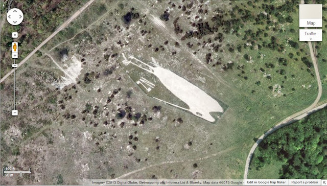
Location (51.194174, -1.715252)


The Fovant Badges (Wiltshire)

On the A30 near to the village of Compton Chamberlayne and south-east of the village of Fovant, a series of chalk military badges can be found which are known as The Fovant Badges.

Similarly to the Compton Chamberlayne “Australia”, The Fovant Badges were initially created by soldiers who were stationed in the area waiting to go to France in 1916 to fight in World War I, and further badges were added over time. At one point there were twenty badges, but today only eight of these originals remain (plus a ninth, crudely cut YMCA badge).
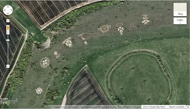
Location (51.053966, -1.978615)


The Lamb Down Badge (Wiltshire)

The Lamb Down Badge is located east of the village of Codford and to the north of the A36. The badge is the emblem of the Australian Commonwealth Military Forces and is known as the “Rising Sun Badge”. The badge was cut in 1916/1917 by Australian troops who were based in the area.

The badge measures approximately 175 ft by 150 ft.
Location (51.153785, -2.024468)


The Shoreham Memorial Cross (Kent)

The Shoreham Memorial Cross can be found north-west of Shoreham (Kent) on the edge of Meenfield Wood. The chalk cross was constructed in 1920 and was designed as a memorial to local men who died during World War I.
Location (51.336613, 0.17315)


The Lenham Memorial Cross (Kent)

The Lenham Memorial Cross can be found to the north-east of the village of Lenham, carved into the slope of the North Downs (near The Pilgrim’s Way/North Downs Way). As its name suggests the cross is a war memorial, which was constructed in 1922 to originally commemorate those who died in World War I. The cross is approximately 200 ft across and was apparently filled in during World War II, to prevent it being used as a navigational aid by attacking German aircraft.
Location (51.242391, 0.729064)


The Whipsnade White Lion (Bedfordshire)

The Whipsnade White Lion lives just to the west of Whipsnade wildlife park, between Dunstable Road (B4506) and Escarpment Avenue. The lion is a large beast, measuring in at around 500 ft in length. The lion was constructed in 1933, and like many other chalk figures it was covered during WWII to prevent it being of use to German pilots.
Location (51.848657, -0.554436)


The Brighton White Hawk (East Sussex)

The Brighton White Hawk can be found in the Whitehawk area of Brighton, to the east of town, and just east of the Whitehawk football ground. The White Hawk, which is now rather faded, can be found by a keen eye between the White Hawk football ground and the golf course.

It seems that the hawk was created in late 2001.
Location (50.82113, -0.09321)


The fading Brighton White Hawk completes the list of the hill figures that I was able to locate using the power of Google Maps. It seems that Britain has been home to a large number of other hill figures over the years, however many seem to have been lost due to a lack of maintenance or via other destructive influences. If I find out about any more they will be posted here!

Pictures, Google Maps (September 2013).

If you find this post interesting please share it using the buttons below.